
UNIGIS Cracow has been launched to fill the gap in the university curriculum. Nowadays, it is a respected training centre that offers specific programs tied to the needs of the private and public sectors. In the interview with Aneta Szablowska-Midor, the UNIGIS studies coordinator, we discussed its 18 years of history.
What was the main motivation to launch the UNIGIS programme?
We started operating as UNIGIS Kraków centre at the Jagiellonian University in 2004. The motivation to launch the UNIGIS programme was pretty obvious: geoinformatics was then a relatively new field, and few university departments in Poland, both within full-time (MSc) and post-graduate studies, had this subject in their offer.
How does the UNIGIS differ from other GIS postgraduate studies?
First, we are a part of a broader community – the UNIGIS International Association. UNIGIS is a network of universities around the world that teach geoinformatics at a distance. The UNIGIS International community on LinkedIn has over 2,000 members. Our website on LinkedIn brings together alumni and supporters of the UNIGIS Kraków centre.
Next, we focus on distance learning. Dozen’s years of experience helped to build the teaching team who knows and understands the challenges faced by e-learning students well before the COVID-19 pandemic.
Join UNIGIS international community to be up to date with current development
Finally, our studies differ from many other programmes due to the profile of our students: those who choose distance learning are people with an active lifestyle who appreciate the convenience and flexibility that e-learning offers. Many of them work abroad. Thanks to the UNIGIS offer, they can study at the Polish University.
What were the most significant changes in the program since the start?
During 18 years, quite a lot of changes took place in the field of GIS&T (Geographic Information Science & Technology). When teaching in this field, a pre-requisite is to follow the changes as closely as possible, and this was the case with UNIGIS studies.
We started with a study program in English prepared by the Geoinformatics Centre of the University of Salzburg (ZGIS). After 10 years of this cooperation, we managed to prepare our own study programme, which covers the main geoinformation fields like geospatial data models, geospatial data acquisition, analysis and visualisation.
Z_GIS department of the University of Salzburg is a close partner of the HES-GEO project. Read the recent wrap-up of the study visit.
We have tried to follow also the various trends of GIS&T development over the last two decades. For example, LIDAR – Light Detection and Ranging becoming a major data acquisition technology, building European infrastructure for spatial information (INSPIRE) and increasing the availability and use of big data and various tools to handle them, like Google Earth Engine, programming for GIS in R and Python.
What has changed only a little is our main teaching philosophy. We believe that an understanding of mechanisms and processes is much more important and brings more timeless benefits for our students than the mindless ability to operate any GIS application. It seems to us that such skills are something worth investing in.
Who are the typical participants of the UNIGIS study programme?
The studies are for people who are working or want to work in professions dealing with spatial aspects of our life. Nowadays, many industries need to collect information about the location of their infrastructure, customers, area of the company influence and possible expansion, and distances to different objects. The same also goes for municipalities, various governmental institutions and local governments that need to take sustainable decisions based on reliable data. Therefore, our students have diverse educational backgrounds and work in various sectors of the economy.
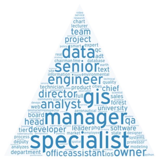
We have geographers, surveyors, ecologists, foresters, GIS specialists, IT specialists, archaeologists, city planners, market analysts, tourism workers and many more. Diversity is typical for UNIGIS participants. After graduating from our studies, some of them are promoted in their current jobs, and some of them get new positions. In some way, we can follow these changes on our website on LinkedIn. The image below reflects the current positions of UNIGIS graduates based on data collected within this social networking site.
Is the profile of participants changing?
Yes, because since the beginning, we have used to target different groups of candidates. In the first stage of our activity, we directed our offer to people looking for an extensive program in the field of GIS&T. In addition, we dedicated two intakes to employees of enterprises under EU-funded programs, which allowed us to train a large group of people
READ THE GRADUATE’S EXPERIENCE
What I definitively learned from UNIGIS was that GIS is a solution to almost any spatial everyday life problem and that cartographic techniques are fantastic tools to present answers to all your questions. Another thing I realized thanks to UNIGIS was that there’s always more than one way to solve any GIS problem, and there’s a huge amount of GIS resources out there: on the internet. If the road you have taken appears to be a dead end, take one step back, dig into the web a little and let it lead you in the right direction. I started my working path as a web developer, and thanks to UNIGIS, I ended up being someone way cooler – a web GIS developer.

With the passage of time, when the subject of geoinformatics was included in the educational programmes of Polish high schools, we decided to teach this issue using our own geographical competencies and based on Polish realities and examples of GIS technology applications. Now we direct our offer to people looking for typical postgraduate studies who need to gain, organize and improve their GIS&T knowledge and skills and understand where their professional competencies lie in the broader image of the discipline.

Aneta Szablowska-Midor works at the Institute of Geography and Spatial Management of Jagiellonian University in Cracow and currently is a UNIGIS studies coordinator and Horizon 2020 project officer.
